

It is difficult to overestimate the importance of the ocean for mankind and animal life on our planet. Covering 70% of the Earth’s surface, the ocean is the world's largest source of oxygen and absorbs 50 times more carbon dioxide than the atmosphere. Climate is regulated by the ocean heat transport, making our world a habitable place.
For human beings, the ocean is also a source of food, economic resources, travel, and leisure activities. Fish accounts for about 17% of the animal protein consumed globally (FAO, 2020). The economic activities associated with the ocean are many and of crucial importance. For example, the FAO estimates that 59.6 million people in the world are engaged in fisheries activities. Only in the European Union, it is estimated that the blue sector employs almost three and a half million workers. World commerce heavily depends on marine transportation; approximately 50 thousand ships trade internationally, representing 80-90% of world trade (Schnurr and Walker, 2019). About 40% of the world population lives along coasts, which are now endangered by the sea level rise due to climate change and are of paramount importance for economic activity.
These facts and figures highlight that ocean forecasting is considered as a vital activity. The first scientific successful ocean forecasting method was developed during the second world war to facilitate the landings of the US Navy. Swell forecasts were produced by analyzing wind speeds and fetch extension. The first modern approaches, based on the use of numerical models (Pinardi et al., 2017), were developed during the 1950s with the establishment of the basics of storm surge forecasting (Hansen, 1956). Other relevant advances, including first 3-dimensional simulations, took place during the 1960s. Good examples of these achievements can be found on estuarine (Shubinski et al., 1965) and general circulation modeling (McWilliams, 1966).
Since those early successes, thanks to an ever-increasing computing capacity, ocean forecast techniques have evolved to what is today a complex body of codes, data and technologies able to deal with the non-linear and chaotic nature of ocean processes. Today, the scientific modeling community is committed to improve the reliability of the forecasts, mainly advancing on three leading edge areas: data assimilation, coupled forecasting and ensemble modeling.
Advances in computer power have played a relevant key in the progress of the discipline. Figure 1.1 shows the dramatic increase in supercomputing power during the last decades, from the first transistor-based machines to the present day petascale computing.

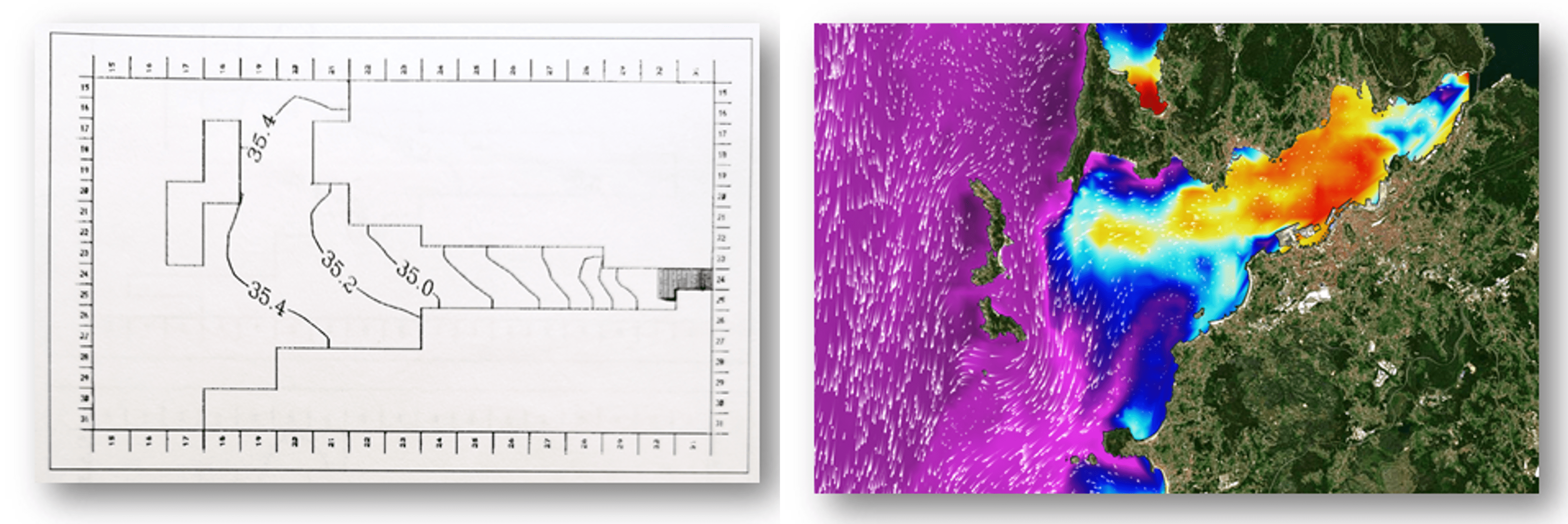
The following example illustrates the evolution of ocean forecasting over the last three decades. Figure 1.2 shows the output of two numerical simulations over the same area executed by the same team. The figure on the left was the result of a 1991 state-of-the-art 3D-baroclinic simulation covering the Ria de Vigo. It was the first simulation of this kind in that area, an estuary in the northwest of Spain. The right plot in Figure 1.2 shows a screenshot of the Portus system (Álvarez Fanjul et al., 2018) in the same geographical domain, as generated by an operational system running 3 decades later.
The differences between both simulations, summarized in Table 1.1, are striking and demonstrate the great evolution that has taken place in the discipline.
The ocean forecasting discipline includes much more than the execution of the numerical models. There are several steps to transform the data produced into accessible and usable information. The downstream activities to produce tailored services and to serve all kinds of final users are more and more frequent and relevant. This creates a network of scientists, public institutions, private companies, and final users that today is driving the modeling community in a virtuous loop driven by the needs of the users.
| 1991 Ria de Vigo simulation | 2021 Portus Operational system | |
|---|---|---|
| Type of simulation | R&D offline simulation | Fully operational simulation integrated into a service, operated 24/7 |
| Spatial resolution | 800 meters | 40 meters |
| Input | Climatological wind, rivers and boundary conditions | Operational, daily update, wind, rivers and boundary conditions |
| Execution time | Several hours of simulation per day | Minutes of simulation per day |
| Storage | Magnetic tape | Solid State Disk |
| Output | Mechanical plotter | Internet, available immediately at global level |
| Downstream applications | No | Several downstream applications (alert systems, oils spill, etc.) |
Table 1.1. State-of-the-art of ocean forecast systems in 1991 and 2021.
The main objective of this guide is to promote the development of new marine forecasting systems around the globe along with the improvement of the existing ones, compiling and making available valuable information to the professionals in charge of developing these services. In writing the various chapters, the authors assumed that the reader has a general knowledge on ocean science but little or no background in ocean modeling. The present book intends to provide an overview of the entire value chain of an Operational Ocean Monitoring and Forecasting System (OOFS), explaining its basis. This guide will also focus, although to a lesser extent, into the more recent technical advances in the sector.
This publication, after the present introductory chapter, has the following structure:
- Chapter 2: Motivation and international context of ocean forecasting. This chapter describes the activities of the Expert Team on Operational Ocean Forecasting Systems (ETOOFS) and its connections with the World Meteorological Organization (WMO) and the Joint Technical Commission for Oceanography and Marine Meteorology (JCOMM). Special focus is made on Copernicus Marine Service and other well-established initiatives. Recent advances in open data policy are introduced, such as the Inspire Open Data Directive. The socio-economic impact of ocean forecasting is described by three pillars: applications, climate and ocean health.
- Chapter 3: Definition of ocean forecasting systems: temporal and spatial scales solved by marine modeling systems. This section includes a description of the various temporal and spatial scales involved in ocean modeling, explaining the differences between products derived from large time scales runs (such as re-analysis and scenarios) and forecasting services. It also deals with the significant variations found in the physics and numerical schemes associated with the different spatial scales (global, regional and coastal). This matter is further deepened for each variable in chapters 5 to 9.
- Chapter 4: Architecture of ocean monitoring and forecasting systems. It contains a general description of the common aspects to all ocean forecasting systems. It explains the basics related to system architecture (inputs, execution, outputs, etc.), quality control and products. The content of this section works as a template to the topics that will be developed in chapters from 5 to 9.
- Chapters 5 to 9: Detailed description of ocean forecasting systems, depending on the variable treated (chapter 5 for Circulation modeling, 6 for Sea-ice, 7 for Sea level and Storm surge modeling, 8 for Wave modeling, 9 for Biogeochemical modeling). The purpose of these chapters is to make understandable, even for non-expert readers, all theoretical and practical basis to properly set-up a forecasting system for a given variable. These chapters provide the physical background on the discipline.
- Chapter 10: Coupled prediction: integrated atmosphere–wave–ocean forecasting. In this chapter it is explained the importance of considering the processes described in previous chapters in an integrated way.
- Chapter 11: Downstream applications: from data to products. This chapter deals with the way the output data from models are transformed into tailored information for the end user. Examples are made for: web pages and other dissemination mechanisms, oil spill forecasting, alert systems, search and rescue, navigation aid, and fisheries.
- Chapter 12: Challenges and future perspectives in ocean prediction. Future development and expectations in the field of ocean forecasting are described in the final chapter.
There is no claim of having included in a single monograph all the knowledge and beauty of ocean modeling. This guide hopes to be a guideline and inspiration to professionals all around the globe, stimulating the reader to research deeper knowledge on this vast field. If this objective is achieved, this publication is expected to foster the generation of valuable information that will be used in decision making processes and, therefore, to advocate a wiser and more sustainable relation with our always generous ocean.
Follow us