Chapter 3

Definition of ocean forecasting systems: temporal and spatial scales solved by marine modeling systems


CHAPTER
COORDINATORS

Enrique Alvarez Fanjul
CHAPTER
AUTHORS

Marcos Garcia Sotillo and John Wilkin

3.3 The spatial scales: downscaling for higher resolutions

Ocean dynamics are described through equations of motion (the Navier–Stokes equations) that are well established for ocean physics (mass, momentum and heat). However, these equations formally apply to the continuum level, whereas in ocean forecasting they are solved on a computational grid with a finite number of cells and discrete resolution. Furthermore, in virtually all computational environmental fluid dynamics fields approximations are made to the governing equations to make their solution tractable. The trade-offs between model resolution, ocean dynamical processes resolved, and computational effort are discussed elegantly by Fox-Kemper (2018). At the outset, ocean modelers are confronted with the key decision of choosing the appropriate spatial resolution for each specific ocean model application. In global operational model applications, relatively coarse resolutions of the order 10s to 100s kilometers are common, whereas in coastal models far higher spatial resolution is needed (perhaps as little as hundreds of meters). The choice of spatial resolution inevitably sacrifices sub-grid-scale dynamical processes that are impractical to explicitly resolve and must instead be somehow parameterized. 

Over the past 30 years there has been a steady evolution in ocean model resolution, in a direct proportion with enhancements and availability of computing resources. This resulted in a finer spatial resolution that allowed significant improvement in the simulation of oceanic flows. A major milestone in the evolution of ocean modeling was the introduction of eddy resolving models. This class of models, with spatial resolution (less than 1/4º in latitude and longitude; or around 25 km) sufficient to allow the spontaneous emergence of ocean mesoscale eddies, was a major ocean model achievement, improving the quality of global simulations and opening the door to accurate regional ocean modeling. However, as described in the next section, this resolution is now eclipsed in global operational systems. 

The continuous increase of resolution along with the progressive enhancement of models was also due to the more explicit inclusion of higher frequency processes, such as the representation of tidal motions and the better representation of turbulence and mixing processes in shallow waters. These improvements have pushed the use of ocean models into the mesoscale resolved and sub-mesoscale-permitting regime, allowing their uses also for coastal purposes. As a result of this progressive evolution of ocean modeling, we have today an ocean model landscape composed of global, regional and local (coastal, littoral and estuarine) model applications. 

The traditional, though in some way artificial, partition between spatial domain extent and model resolution, has been also favored by the fact that operational ocean forecasting centres generate their specific ocean model products for coastal and regional seas following a typical dynamical downscaling approach, which transfers information at large scales from the global solutions to the interior of the nested regional domains (Kourafalou et al., 2015). Spatial scales are directly linked to temporal ones, and adequate temporal resolution is also needed to simulate ocean processes at refined spatial resolution. Hydrodynamic model time steps are always matched to spatial resolution by virtue of numerical stability constraints, but consideration must be also given to adding temporal resolution in external inputs, such as specifying river inflow data at daily or shorter intervals, and resolving in this way the diurnal cycle of solar heating. It should be emphasized that temporal and spatial scales play important roles in ocean model performance, and inappropriate decisions on the spatial-temporal scales to be solved may result in modeling errors. 

As pointed out by Holt et al. (2017), one of the greater challenges in Earth System Modeling science is to get an accurate representation of coastal and shelf seas in global ocean models. Furthermore, applying cutting-edge scientific progress in ocean model systems, which aim at solving the ocean state in the climate system or at supporting monitoring and forecasting systems, is another challenge of the operational ocean services. 

Next sections describe ocean forecasting at the global, regional and coastal scales.

3.3.1 Global monitoring and forecasting systems

Numerous ocean modeling groups and individual researchers operate near real-time systems for the analysis and forecast of ocean mesoscale circulation in global and basin scale domains. They are gathered under the umbrella of the OceanPredict science network (🔗3) that evolved from the GODAE group established in 1999 at the behest of the GOOS sponsored OOPC panel. As a forum for knowledge exchange, OceanPredict fosters communication on best practices and new developments in global ocean modeling, engaging also with regional domain activities and the generation of model-based information products. A component of these activities is the annual reporting on forecast systems run by national centers and multi-national consortia, which maintain a very high level of operational stability and reliability akin to national weather services. In many instances these ocean systems increasingly operate in strict collaboration with weather services, a trend that is strengthening with the emergence of seasonal to sub-seasonal prediction efforts. From OceanPredict 🔗4 annual reports and system descriptions, it can be noted that horizontal resolutions of order 1/12º, or roughly 9 km at mid-latitudes, are widely considered adequate for delivering forecasts useful to numerous stakeholders and users, and to inform subsequent down-scaling efforts. Running global simulations at much higher resolution, such as the 1/48º (~2-3 km) MITgcm LLC4320 model (Su et al., 2020), has proven feasible, and this resolution improves the representation of processes such as the mesoscale to submesoscale turbulent cascade and submesoscale modulated vertical mixing. However, for global forecast systems, the substantial additional cost of advanced DA increases the computational demand of the analysis/forecast cycle by roughly an order of magnitude, making higher resolutions impractical at present. Moreover, there is evidence that existing global observing networks are not able to constrain higher resolutions. Jacobs et al. (2019) suggest that the horizontal scales of motion that are effectively constrained by available sustained observations is of order 36 to 54 km or larger, depending on the metric. When shorter length scales that were notionally resolved by their model (~5 to 10 times the grid resolution) but unconstrained by observation were filtered out of the model prior to computing Lagrangian drifter trajectories, the ensemble trajectory forecast error actually decreased.

3.3.2 Regional monitoring and forecasting systems

Many groups in the OceanPredict network also operate regional domain models encompassing single ocean basins or large marginal seas with enhanced resolutions of about 4 km or even finer, using output from global analysis/forecast systems as open boundary conditions. There are many reasons for this downscaling approach. The familiarity of local experts with regional ocean dynamics allows them to make choices in model configuration that yield more skilful results. For data assimilative systems, there is also the opportunity to incorporate local observations that were not utilized by the parent model operators. Furthermore, regional operators are often better acquainted with, and can be more responsive to, the information product requirements of regional stakeholders. 

The nominal resolutions of some typical regional systems within OceanPredict 🔗5(link is external) are for the seas around Korea of 1 to 3 km and ports at 300 m, the MedFS at 1/24º (~3.5 km), and the JMA at ~2.5 km. Numerous sub-domains in the Indian Ocean run by the INCOIS operate at similar resolutions. 

Some of these systems include advanced DA in the forecast cycle initialization, such as the JMA regional model that uses 4-dimensional variational (4D-Var) assimilation, although this is not the norm. Several Regional Associations of the US IOOS operate down-scaling forecast systems using 4D-Var to incorporate local high-resolution data from autonomous vehicles and surface current measuring HF-radar in domains of several hundred kilometers in extent, but model resolution is in the range 4 to 10 km. The WCOFS operated by the US NOAA CO-OPS is an ambitious regional forecast system covering over 3000 km of the US west coast. Originally conceived as a 2-km model (Kurapov et al., 2017), this proved impractical for real-time DA. Operational WCOFS uses a 4 km grid, for which a complete cycle of 4D-Var takes 5 wall clock hours each day on 480 cores of the National Weather Service high performance computer. 

However, computational cost remains a major constraint on regional model resolution, and the question of whether coastal ocean observing systems have sufficient resolution to inform finer scales remains open. Mixed resolution systems are in development, wherein the forecast model is run at a higher resolution than the DA analysis. In experimental systems there is evidence (Levin et al., 2021) that submesoscale resolving nested models can extract added information from closely spaced observing platforms that capture the unbalanced ageostrophic submesoscale. 

Sotillo et al. (2021) describe an operational system with a model grid downscaling approach. It employs regional downscaling to order 4 km with the purpose of delivering improved resolution for continental shelf seas of the Iberian Peninsula, with subsequent downscaling to ~350 m on selected coastal sectors and further to ~70 m in ports. This hierarchical approach, using similar models at each level of refinement raises a question: what are the differences between a coastal and a regional model? 

The regional forecasting system examples mentioned above mostly use model codes that solve the hydrostatic primitive equations on a structured grid. While the transition to very high-resolution might admit submesoscale stratified dynamics, shallow coastal waters are often well mixed vertically and the processes relevant to ocean prediction for maritime operations have horizontal scales that are long relative to the depth, and consequently the hydrostatic approximation remains valid (Fringer et al., 2019).

The distinction we have made in structuring this section is that coastal models differ from regional models in that submesoscale processes are dramatically constrained by bathymetry while coastline scales are smaller than the Rossby deformation scale. Such processes include lateral and vertical flow separation, secondary flows, headland eddies, wakes, and frontal convergences. Resolution of topographic features that impact such processes is of paramount importance.

3.3.3 Coastal monitoring and forecasting systems

As previously noted, Sotillo et al. (2021) used a set of structured grids in their limited area one-way downscaled nested coastal models for selected ports and coastal segments. One advantage of this strategy is that the computational burden of short time steps demanded by high resolution is limited to the finest grid nests and does not impact the efficiency of the coarse parent grid. 

More complex nested systems employ full coupling of parent and child nests on each time step, including two-way communication of fine scale variability back to the parent, a feature supported in some models such as the Coastal and Regional Ocean COmmunity model (CROCO; 🔗6). A similar nesting framework has been used in the Regional Ocean Modeling System (ROMS; 🔗7) model within the Coupled Ocean-Atmosphere-Wave-Sediment Transport system (COAWST; Warner et al. 2008) to perform numerous research studies of coastal and nearshore circulation and geomorphology, though implementation of this approach in operational systems is rare. 

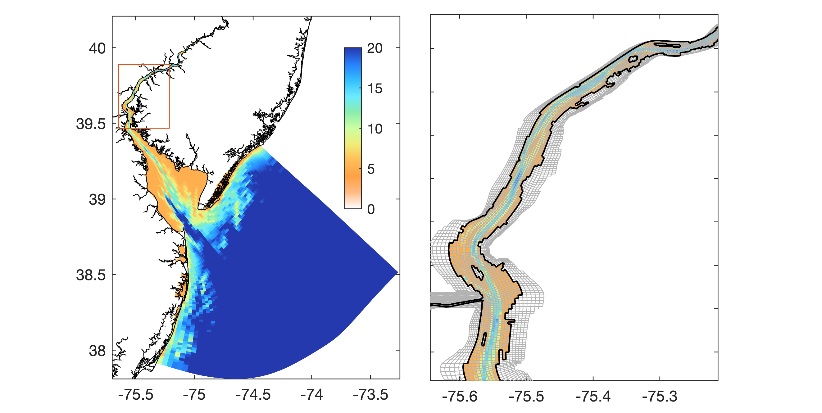
NOAA CO-OPS use the orthogonal curvilinear coordinate facility in ROMS to better represent details of irregular coastline shape and variable bathymetry in a number of estuaries of the U.S. coastal zone. For example, the Delaware Bay Operational Forecast System (DBOFS; 🔗8) uses a curvilinear grid that adapts the model domain to the general shape of the estuary (Figure 3.2) and stretches the grid resolution from 4 km offshore to 40 m within the tidal river. 

Figure 3.2. NOAA CO-OPS Delaware Bay Operational Forecast System (DBOFS) curvilinear grid domain and bathymetry (top) and enlarged view of inset area (bottom) showing the stretch mesh ~40 m resolution in the vicinity of the estuarine salt wedge and tidal river.

However, there are clear limits to the abilities and efficiencies of curvilinear structured grid models for coastal applications. By contrast, unstructured grid models (e.g. FVCOM, ADCIRC, SELFE, SUNTANS; see Fringer et al. (2019) for references on these models) have enormous flexibility to resolve complex bathymetric features. They efficiently resolve multiscale features by adapting grid orientation to follow the coastline or the isobaths, telescoping the resolution to match anticipated scales in the circulation.

Conventional unstructured grid model configurations use the same time step throughout the domain, so regions of coarse resolution are often integrated with a time step vastly less than necessary for accuracy or stability, incurring in a loss of efficiency. But a well-crafted mesh will have a relatively small proportion of cells where the resolution is coarse. For example, the Great Barrier Reef model of Legrand et al. (2006) has 82% of the cells concentrated close to reefs and islands, whereas 25% of the area of the domain far from the coast is captured by less than 1% of cells. 

As its name suggests, the SURF described by Trotta et al. (2021) demonstrates that both approaches to grid design can be implemented within a single system taking advantage of their respective strengths. 

The ability of unstructured grids to resolve exceptional detail locally is illustrated by the application of the Stanford unstructured-grid, nonhydrostatic, parallel coastal ocean model (SUNTANS) to achieve ~1 m horizontal resolution at a convergence zone between tidal channels in the Snohomish River Estuary (Giddings et al., 2012). At this resolution, non-hydrostatic dynamics that are incorporated in the SUNTANS computational kernel can become important. However, in operational settings that encompass much larger domains, fully resolving such coastal submesoscale detail is not feasible, and some attempt at parameterization is necessary. 

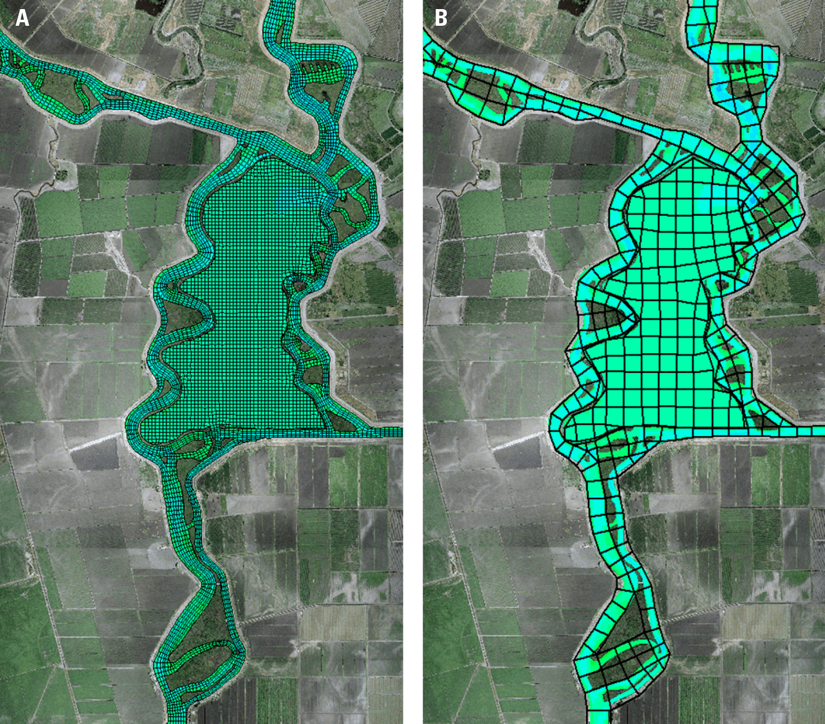
Approaches to parameterizing very high-resolution bathymetry in lower resolution models are discussed by Fringer et al. (2019), who draw particular attention to the sub-grid bathymetry method of Casulli (2009) for improved representation of wetting and drying processes for coastal sea level inundation. This approach, which preserves the cross-section area of cell faces on the basis of bathymetric data available at resolution finer than the model mesh, was used to great effect by MacWilliams et al. (2016) in simulations with the UnTRIM model (Casulli and Zanoli, 2005) of the San Francisco Estuary (Figure 3.3). Accuracy similar to the high-resolution (~10 m) version of the model was achieved with an order of magnitude fewer cells and a 40-fold speed-up in run time. For coastal inundation forecasting – an important application of operational coastal ocean modeling – is essential to follow these careful steps to represent coastal submesoscale bathymetric detail, as well as to achieve acceptable run-time for the timely delivery of forecast guidance. 

Figure 3.3. Comparison between high-resolution (left) and coarse-resolution (right) from the Bay–Delta model grids by the UnTRIM model in the region of Mildred Island, San Francisco Estuary, U.S., showing the savings in resolution with little loss in accuracy by the application of subgrid-scale bathymetry parameterization – from MacWilliams et al. (2016).

The meaningful configuration of an operational system at such high resolution clearly requires the existence of comparable resolution bathymetric data. These are becoming more widely available with the increasing use of airborne LIDAR and concerted efforts to merge independently acquired data sets into unified gridded products with harmonized vertical datum. For example, coastal relief (both water and adjacent land) is digitized at 1/3 arc seconds (~10 m) for many sectors of the US East coast that are subject to frequent storm surge inundation or at tsunami risk, and for most estuaries bathymetric data at 30 m resolution are available.

In contrast to the great challenge of adequately representing horizontal detail in coastal ocean models, vertical resolution is seldom a limitation in operational models. The widespread use in coastal models of terrain following coordinates retains vertical resolution in shallow water; in ROMS and CROCO this can be further stretched toward the surface or seafloor to give added resolution in frictional boundary layers. 

Vertical turbulence closure schemes for operational coastal models are mature, including the parameterization of wave-current interaction processes that modify bed stress, wave radiation stress and Stokes drift, and models can exploit wave data or a wave model if they are available in conjunction with the circulation model. In this topic, there is active research and development on parameterizing the roles of subaquatic vegetation (Kalra et al. 2020) and semi-porous reefs on drag and circulation to adequately represent the drag in flooded areas during unusually severe inundation events. 

Summarizing, the current best practices for multi-scale modeling from global to regional to coastal scales favor global and basin resolutions of order 1/12º, with downscaling to ~4 km in regional seas and sub-kilometer scale in coastal applications, estuaries and ports. This hierarchy of scales in typical applications was corroborated also in reviews such as Holt et al. (2017). 

For coastal domains, unstructured grid models remain popular for the substantial flexibility they offer in representing complex topographic regimes. At regional scales, the choice for the appropriate model is wide and this is reflected in the diversity of model codes used by operational agencies. It should be kept in mind that resolution is only one constraint on model fidelity. Forecast systems benefit from advanced data assimilation in the analysis step that informs the initial conditions of a forecast. While advanced data assimilation at global and basin scales is mature and widely employed in operational systems, these methods have yet to be applied seriously in operational coastal and estuarine environments. 

When this happens, aided by the emergence of comprehensive high-resolution coastal observing networks, they place an added burden on computational effort and may demand reassessment of the resolution necessary to meet the information requirements of stakeholders. 

While it seems unlikely that very small scale nonhydrostatic vertical processes will be resolved in operational systems in the near future, there is progress on their parameterization within conventional primitive equation models (e.g. Dong et al., 2021). There is further ongoing research in both coastal modeling techniques and parameterization of other processes (Fringer et al., 2019) for a comprehensive overview) and many of these developments are expected to advance from research to operations in due course.

References

Benway, H., Lorenzoni, L., White, A., Fiedler, B., Levine, N., Nicholson, D., and DeGrandpre, M., Sosik, H., Church, M., O’Brien, T., Leinen, M., Weller, R., Karl, D., Henson, S., Letelier, R. (2019). Ocean Time Series Observations of Changing Marine Ecosystems: An Era of Integration, Synthesis, and Societal Applications. Frontiers in Marine Science, 6, 393, https://doi.org/10.3389/fmars.2019.00393

Capet, A., Fernández, V., She, J., Dabrowski, T., Umgiesser, G., Staneva, J., Mészáros, L., Campuzano, F., Ursella, L., Nolan, G., El Serafy, G. (2020). Operational Modeling Capacity in European Seas - An EuroGOOS Perspective and Recommendations for Improvement. Frontiers in Marine Science, 7, 129, https://doi.org/10.3389/fmars.2020.00129

Casulli, V. (2009). A high-resolution wetting and drying algorithm for free-surface hydrodynamics. International Journal for Numerical Methods in Fluids, 60(4), pp.391-408, https://doi.org/10.1002/fld.1896

Casulli, V., Zanolli, P. (2005). High resolution methods for multidimensional advection-diffusion problems in free surface hydrodynamics. Ocean Modelling, 10, 137-151, https://doi.org/10.1016/j.ocemod.2004.06.007

Copernicus Marine Service (2021a). EU Copernicus Marine Service, https://marine.copernicus.eu/

Copernicus Marine Service (2021b). Ocean State Report (OSR), https://marine.copernicus.eu/access-data/ocean-state-report

Copernicus Marine Service (2021c). Ocean Variables monitored by Copernicus Marine Service and Product Portfolio https://marine.copernicus.eu/access-data/ocean-monitoring-indicators

 Collins, M., Knutti, R., Arblaster, J., Dufresne, J.-L., Fichefet, T., Friedlingstein, P., Gao, X., Gutowski, W.J., Johns, T., Krinner, G., Shongwe, M., Tebaldi, C., Weaver, A.J., Wehner, M. (2013). Long-term Climate Change: Projections, Commitments and Irreversibility. In “Climate Change 2013: The Physical Science Basis. Contribution of Working Group I to the Fifth Assessment Report of the Intergovernmental Panel on Climate Change [Stocker, T.F., D. Qin, G.-K. Plattner, M. Tignor, S.K. Allen, J. Boschung, A. Nauels, Y. Xia, V. Bex and P.M. Midgley (eds.)]”. Cambridge University Press, Cambridge, United Kingdom and New York, NY, USA. 

Dong, J., Fox-Kemper, B., Zhu, J., and Dong, C. (2021). Application of symmetric instability parameterization in the Coastal and Regional Ocean Community Model (CROCO). Journal of Advances in Modeling Earth Systems, 13(3), https://doi.org/10.1029/2020MS002302

Fox-Kemper, B. (2018). Notions for the motions of the oceans. In “New Frontiers in Operational Oceanography”, Editors: E. P. Chassignet, A. Pascual, J. Tintoré, and J. Verron (Exeter: GODAE OceanView), 811, https://doi.org/10.17125/gov2018.ch02

Fringer, O.B., Dawson, C.N., He, R., Ralston, D.K. and Zhang, Y.J. (2019). The future of coastal and estuarine modeling: Findings from a workshop. Ocean Modelling, 143, 101458, https://doi.org/10.1016/j.ocemod.2019.101458

GCOS Global Climate Observing System. (2021). Essential Climate Variables https://gcos.wmo.int/en/essential-climate-variables

Giddings, S.N., Fong, D.A., Monismith, S.G., Chickadel, C.C., Edwards, K.A., Plant, W.J., Wang, B., Fringer, O.B., Horner-Devine, A.R., Jessup, A.T. (2012). Frontogenesis and frontal progression of a trapping-generated estuarine convergence front and its influence on mixing and stratification. Estuaries and Coasts, 35, 665-681, https://doi.org/10.1007/s12237-011-9453-z

Holt, J., Hyder, P., Ashworth, M., Harle, J., Hewitt, H. T., Liu, H., New, A. L., Pickles, S., Porter, A., Popova, E., Allen, J. I., Siddorn, J., and Wood, R. (2017). Prospects for improving the representation of coastal and shelf seas in global ocean models, Geoscientific Model Development, 10, 499-523, https://doi.org/10.5194/gmd-10-499-2017

Jacobs, G.A., D’Addezio, J.M., Bartels, B. and Spence, P.L. (2019). Constrained scales in ocean forecasting. Advances in Space Research, 68(2), 746-761, https://doi.org/10.1016/j.asr.2019.09.018

Kalra, T.S., Ganju, N.K., and Testa, J.M. (2020). Development of a submerged aquatic vegetation growth model in the Coupled Ocean-Atmosphere-Wave-Sediment Transport (COAWST v3.4) model. Geoscientific Model Development, 13(11), 5211-5228, https://doi.org/10.5194/gmd-13-5211-2020

Kourafalou, V. H., De Mey, P., Staneva, J., Ayoub, N., Barth, A., Chao, Y., Cirano, M., Fiechter, J., Herzfeld, M., Kurapov, A., Moore, A. M., Oddo, P., Pullen, J., Van der Westhuysen, A., and Weisberg, R., (2015). Coastal Ocean Forecasting: science foundation and user benefits. Journal of Operational Oceanography, 8:sup1, s147-s167, https://doi.org/10.1080/1755876X.2015.1022348

Kurapov, A. L., Pelland, N. A., and Rudnick, D. L. (2017). Seasonal and interannual variability in alongslope oceanic properties off the US West Coast: Inferences from a high-resolution regional model. Journal of Geophysical Research: Oceans, 122(7), 5237-5259, https://doi.org/10.1002/2017JC012721 

Legrand, S., Deleersnijder, E., Hanert, E., Legat, V. and Wolanski, E. (2006). High-resolution, unstructured meshes for hydrodynamic models of the Great Barrier Reef, Australia. Estuarine, Coastal and Shelf Science, 68(1-2), 36-46, https://doi.org/10.1016/j.ecss.2005.08.017

Levin, J., Arango, H., Laughlin, B., Hunter, E., Wilkin, J., Moore, A. (2021), Observation Impacts on the Mid-Atlantic Bight Front and Cross-Shelf Transport in 4D-Var Ocean State Estimates, Part II – The Pioneer Array. Ocean Modelling, 157, 101731, https://doi.org/10.1016/j.ocemod.2020.101731

MacWilliams, M., Bever, A.J. and Foresman, E. (2016). 3-D simulations of the San Francisco Estuary with subgrid bathymetry to explore long-term trends in salinity distribution and fish abundance. San Francisco Estuary and Watershed Science, 14(2), https://doi.org/10.15447/sfews.2016v14iss2art3

Muller-Karger, F.E., Miloslavich, P., Bax, N.J., Simmons, S., Costello, M.J., Sousa Pinto, I., Canonico, G., Turner, W., Gill, M., Montes, E., Best, B.D., Pearlman, J., Halpin, P., Dunn, D., Benson, A., Martin, C.S., Weatherdon, L.V., Appeltans, W., Provoost, P., Klein, E., Kelble, C.R., Miller, R.J., Chavez, F.P., Iken, K., Chiba, S., Obura, D., Navarro, L.M., Pereira, H.M., Allain, V., Batten, S., Benedetti-Checchi, L., Duffy, J.E., Kudela, R.M., Rebelo, L.-M., Shin, Y., Geller, G. (2018). Advancing Marine Biological Observations and Data Requirements of the Complementary Essential Ocean Variables (EOVs) and Essential Biodiversity Variables (EBVs) Frameworks. Frontiers in Marine Science, 5:211, https://doi.org/10.3389/fmars.2018.00211

Pérez, B., Brouwer, R., Beckers, J., Paradis, D., Balseiro, C., Lyons, K., Cure, M., Sotillo, M. G., Hackett, B., Verlaan, M., Alvarez-Fanjul, E. (2012). ENSURF: multi-model sea level forecast implementation and validation results for the IBIROOS and Western Mediterranean regions. Ocean Science, 8, 211-226, https://doi.org/10.5194/os-8-211-2012

Randall, D.A., Wood, R.A., Bony, S., Colman, R., Fichefet, T., Fyfe, J., Kattsov, V., Pitman, A., Shukla, J., Srinivasan, J., Stouffer, R.J., Sumicand, A.,Taylor, K.E. (2007). Climate Models and Their Evaluation. In “Climate Change 2007: The Physical Science Basis. Contribution of Working Group I to the Fourth Assessment Report of the Intergovernmental Panel on Climate Change [Solomon, S., D. Qin, M. Manning, Z. Chen, M. Marquis, K.B. Averyt, M. Tignor and H.L. Miller (eds.)]”. Cambridge University Press, Cambridge, United Kingdom and New York, NY, USA.

Schiller, A., Mourre, B., Drillet, Y., Brassington, G. (2018). An overview of operational oceanography. In “New Frontiers in Operational Oceanography”, E. Chassignet, A. Pascual, J. Tintoré, and J. Verron, Eds., GODAE OceanView, 1-26, https://doi.org/10.17125/gov2018.ch01

Sloyan, B.M., Wilkin, J., Hill, K.L., Chidichimo, M.P., Cronin, M.F., Johannessen, J.A., Karstensen, J., Krug, M., Lee, T., Oka, E. and Palmer, M.D. (2019). Evolving the physical global ocean observing system for research and application services through international coordination. Frontiers in Marine Science, 6, 449, https://doi.org/10.3389/fmars.2019.00168

Sotillo, M.G., Mourre, B., Mestres, M., Lorente, P., Aznar, R., García-León, M., Liste, M., Santana, A., Espino, M., Álvarez, E. (2021) Evaluation of the Operational CMEMS and Coastal Downstream Ocean Forecasting Services During the Storm Gloria (January 2020). Frontiers in Marine Science, 8:644525, https://doi.org/10.3389/fmars.2021.644525

Su, Z., Torres, H., Klein, P., Thompson, A. F., Siegelman, L., Wang, J., Menemenlis, D., and Hill, C. (2020). High-frequency Submesoscale Motions Enhance the Upward Vertical Heat Transport in the Global Ocean. Journal of Geophysical Research: Oceans, 125(9), id. e16544, https://doi.org/10.1029/2020JC016544

Trotta, F., Federico, I., Pinardi, N., Coppini, G., Causio, S., Jansen, E., Iovino, D. and Masina, S. (2021). A Relocatable Ocean Modeling Platform for Downscaling to Shelf-Coastal Areas to Support Disaster Risk Reduction. Frontiers in Marine Science, 8, 317, https://doi.org/10.3389/fmars.2021.642815

Warner, J.C., Sherwood, C.R., Signell, R.P., Harris, C.K., and Arango, H.G. (2008). Development of a three-dimensional, regional, coupled wave, current, and sediment-transport model. Computers and Geosciences, 34(10), 1284-1306, https://doi.org/10.1016/j.cageo.2008.02.012

WMOWorldMeteorologicalOrganization(2021). Definitions,requirements, andnetwork informationof ECVs (ECV-Oceanmatrix) https://public.wmo.int/en/programmes/global-climate-observing-system/essential-climate-variables.

To start contributing, sharing knowledge and editing the WIKI, please login